"North to Alaska", well maybe just the Yukon
- Sep 9, 2017
- 11 min read
Updated: Jul 23, 2023


Land of the Midnight Sun or midnight daylight is more accurate (the photo at the right was taken at 10:43 PM). As we travelled north, the daylight hours became longer and longer. By the time we reached Whitehorse, darkness never appeared in the sky. There was always some light around. We had to consciously think about going to bed as it was so light out.
Liard River is almost at the BC/Yukon border so after several stops for Wood Bison and black bear along the way, we arrived in Watson Lake at 2 PM and got the last room at the “Nice Motel”. Accommodations have been filling up as the summer progresses so that means we have to plan ahead a bit more – don’t want to spend the night trying to sleep in the car, thank you very much.
Watson Lake, Yukon
In Watson Lake, we walked down to the Sign Post Forest where we were told there are somewhere between 75,000 and 82,000 signs, mostly displaying travelers' home location. This tradition was started about 75 years ago when the American army was building the Alaska Highway. There are so many signs it was overwhelming and impossible to get a photo that shows the magnitude of the display. But here is an attempt to capture the ‘forest’ and some of the signs.


Walked up to the Northern Lights Centre and watched a film on the Aurora Borealis phenomena. It was well done and the colours were incredible. We have seen the northern lights in Victoria on several occasions but nothing like what we saw in the film. Makes you wonder about flying up to this area during the winter as many Asians do (March is apparently the best month – less chance of overcast skies or bitterly cold temperatures). When we came out of the Centre, it was starting to rain so we dashed into a grocery store and bought the fixings for dinner and breakfast. Watched “Guardians of the Galaxy” (Part 1) on DVD. It was good for a few laughs but Part 2 is even better.
Next morning, we packed but before we loaded the Jeep we did some birding around Wye Lake, right near the town (Watson Lake itself is a few miles away). Got 8 species in about an hour but nothing new to us.
The highway turns west at this point and drops back into BC before hitting Whitehorse. One stop in the Yukon was at Rancheria Falls. These 2 waterfalls are created by an island in the middle of the river. It was a short walk thru the boreal forest along a boardwalk.
We also saw a female moose eating from a swampy area, near here.


Just passed here, along the roadside, we found a sow black bear with 3 cubs! This was a most unusual find and Jeannie got some good photos before mom shooed the cubs into the woods. She was covered with flies (the white dots).


Stopped for a picnic lunch near Teslin and got some photos of a Gray Jay (aka Whiskey Jack). Along the side of the road in this area, for hundreds of kilometres, you can see evidence of a volcanic explosion from many, many years ago (see arrow pointing to the layer).


Also stopped at the Teslin Tlingit Heritage Centre where we had some interesting conversations with the Tlingit ladies there. One showed us how she prepares and tans the moose hides for clothing. She made a lovely presentation in the true First Nations style with lots of little anecdotes and humour.

Whitehorse

We pushed onto Hidden Valley B & B in Whitehorse in the Yukon
( https://www.yukonbedandbreakfast.com ). One of the managers at Hidden Valley had worked with Jim at the Royal BC Museum many years ago. It was great to reconnect with Tara and meet her partner, Scott who is a creative chef at the B&B and teaches cooking classes. We spent 4 nights with them since there was much to see in Whitehorse. Friends from Victoria had stayed at Hidden Valley B&B last year and some of the current guests were from Parksville, where Jeannie’s mom lived for 11 years – small world.


Our first outing in Whitehorse was just up the highway at the Yukon Wildlife Preserve. These 700 acres are home to 13 species of northern Canadian large mammals of the area. They display the animals in a natural-like environment and do conservation and rehabilitation work. We wandered the property for 5 hours as there were many birds to see as well.
Click on the photo below to see the slideshow of the critters at the Preserve or use the arrows (<>) to move forward and back.


Tara, at the B&B, was kind enough to speak to a local birding expertise and gave us a number of spots to check out, the most productive being, McIntyre Marsh. We were ever hopeful of seeing a Golden Eagle who hangs out at the garbage dump near there but saw many juvenile Bald Eagles instead. Whitehorse is home to the world's largest weather wave, a old DC3 which flew many hours in the Yukon.


Carcross
It was recommended by several people to visit Carcross, the terminus of the White Pass Railway from Skagway, Alaska. It was known as Cariboo Crossing but there were too many spots with that name so they shortened it to Carcross.


Emerald Lake


We stopped at Emerald Lake on the way to Carcross (photo above). The lake is beautiful but Jim found their signs most interesting. There was the symbol of a camera and then a big question mark. Does that mean that they don’t know what it is but you really should take a picture of it?
Only a few kilometers away from Emerald Lake is an inland desert with large sand dunes that are constantly on the move and have crossed the highway. Lots of people in dune buggies and quads out on the sand.
Back to Spirit Lake Wilderness Lodge where we met Cris Guppy and Aud Fisher for lunch. Jim had worked with both these lovely folks at the museum, many years ago. Check out Aud’s YouTube videos of baby mice (CreekValleyCritters) – she has quite a following. Then we ran into Cris again at the Whitehorse Tim Horton a few days later so shared our lunch time with him (small world - again).
Haida Gwaii (almost)
One of the mornings at Hidden Valley B&B, we spent trying to arrange a tour on Haida Gwaii (Queen Charlotte Islands) as we were going to be in that area later in our trip. We were able to organize most of it but our car was waitlisted on the ferry between Prince Rupert and Skidegate. We tried to arrange some fall back measures such as flying or renting a car or finding a parking spot for our potentially deserted car. After much agonizing, we decided to cancel that part of the trip as there were too many unknowns. Maybe something we can plan for next summer when we can fly from Vancouver (no flights from Prince Rupert to Sandspit – arrrgh).
Beringia is the name given to the land, now under the Bering Sea, which was exposed during the last ice age. Displays at the Yukon Beringia Interpretive Centre shows what animals inhabited this area 10,000 years ago. We saw 2 excellent films which use computer graphics to explain how it all may have happened 12,000 years ago.


Klondike Highway
The road from Whitehorse to Dawson City (the Klondike Highway – a mispronounciation of the Tr’ondek Hwech’in people) is well maintained but the last 100 km south of Dawson City is a bit rougher due to the frost heaves in the road bed over the muskeg. BUT the road can be dusty if the gravel hasn’t been capped with tar – they use tar rather than pavement as it’s more forgiving in the cold and heat.


One of the overlooks on the Klondike Highway is the Five Fingers Rapids. This major obstacle on the Yukon River was a challenge to the steamboats travelling between DC and Whitehorse. You can just look from the highway viewpoint or walk along a 2 km trail to overlook the main passageway taken by the steamboats – the challenge is the 222 stairs on the way back up. We happened to stop the first time as a Holland America Line (HAL) bus stopped to disgorged its passengers (so we stopped again on the way back down). We saw 3 different HAL buses while in Dawson City. They carried cruise ship passengers who were travelling between Skagway and Anchorage overland to see the Gold Rush trail.


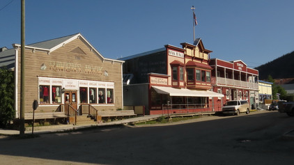
Dawson City
Dawson City is very much a tourist town which probably makes most of it's money between May and September, other than some gold mining which still continues in the vicinity. They have tried to preserve as much of the old town as possible to recreate buildings in the style from 1896 when the town exploded after gold was found nearby
( http://tc.gov.yk.ca/archives/klondike/en/discovery.html ). The sidewalks are still wooden and the roads are not paved. New structures are built to resemble the old buildings. The large slide which is just above the 'city' (Moosehide Slide because it looks like a moosehide stretched out for tanning) was not the result of the gold rush excavations but is recorded in the First Nations oral history.


The first morning, we decided to wander the streets and found the old Robert Service (the poet) Cabin – recreated as it would have been in 1908 (now a Parks Canada site.) Over to Jack London’s cabin but they were doing some filming so we didn’t see inside (he wrote “Call of the Wild” and “White Fang”). Pierre Burton’s family home is labelled but it is not open to the public. Since this was the residential part of the town, we saw a few birds, as well.


One evening, we paid $12 a head and attended Diamond Tooth Gertie’s Gambling Hall to see the dance routine/show held several times a night. The next day, we noticed that several of the dancers were also the waiters at Sourdough Joe’s Restaurant and one of the singers was the clerk in Jimmy’s Place. The dancers also came in full CanCan dress to the Canada Day festivities.


We started Canada Day at one of the local churches for a Pancake Breakfast, where we talked to a local character who gave us lots of information about how they build homes because of the permafrost and employment. Next was the parade, which lasted about 8 minutes but was enjoyed by the kids riding their bikes and the tourists cheering from the sidelines.


Attended a gold panning contest in which the contestants actually got to keep the gold they found (but it cost them $10 each to enter). Each contestant had the same amount of gold to find in their bucket of dirt and the one who found the most gold in the shortest period of time was the winner. The water where they were panning was very cold!


We visited the Danoja Zho Cultural Centre by the river for some bannock, a short video presentation and exhibits. The Truth and Reconciliation Commission has been a stepping stone for some aboriginal communities to begin their healing. We saw and heard about community based projects where residential school survivors have begun to move forward into reconciliation while strengthening their youngster’s cultural understanding. The “Seeds of Change” project was a multi-medium exhibit which engaged the survivors and the public.
In the spring of 2016 the K’änächá Residential School Survivors group, their families and the Tr’ondëk Hwëch’in Health and Social Department brought to light that many citizens were now ready to speak openly about reconciliation . The group planned to do this by presenting a public gathering on National Aboriginal Day and erecting a plaque about residential school on the Dawson City waterfront. This idea blossomed into an exhibition of art, story, film and objects that reflect “why we are the way we are,” the steps forward as a community, the story of the intergenerational effects of residential school and provide an opportunity for the artists of our community as well as guests to express their understanding and desire for reconciliation at a community and national level.
From the Yukon Arts Centre website: http://yukonartscentre.com/calendar/event/seeds-of-change-calls-to-action-and-faye-chamberlains-cutting-through-red-t/
We had read about the placer mining operations from 1898 which resulted in the Klondike Gold Rush. Although the majority of the gold was removed in just 2 years by hand, the effects of the later excavations are still obvious. As we first drove into town, we noticed large piles of round stones along the roadside (we photographed them from Dome Mountain for a better overview - see below). These piles of stones were the tailings of the creek dredges used to remove the overburden of soil, etc to get to the gold flakes sitting on the bedrock. Many years ago, one of the Dredges (#4) was restored and opened as a National Historic Site. Wiki has a good explanation of it's operation https://en.wikipedia.org/wiki/Dredge_No._4 .


Our best dinner in Dawson City was at Klondike Kate’s, even if we did have to wait for about an hour for our meal. The 19th Annual Yukon River Quest Canoe and Kayak Race had ended that day so there were a lot of hungry paddlers in town looking for a good meal (note the canoe in the clear waters of the Klondike River, beside the paddlesteamer in the muddy waters of the Yukon River, which flows from BC to the Bering Sea in Alaska). If you are curious about this 715 kilometre wilderness river race, have a look at the Rules and Preparation page on their website: https://www.yukonriverquest.com/
Kluane National Park
On leaving Dawson City, we didn’t do the loop over the Top of the World Highway and into Alaska as planned, because of poor weather and low visibility (not much point in travelling into the high mountains to see the sights when all we’d see would be clouds). So we drove back to Whitehorse, we counted 65 RVs coming north. RV travel is such a good idea up here as there are many campgrounds and pull-offs along the highways that are usable.
At Whitehorse, we turned north and drove part way up the Alaska Highway to Haines Junction. The mountains of Kluane National Park are almost as outstanding as the Rockies. We had lunch at the Village Bakery but passed on the cinnamon buns as we are getting a bit carbed out ( http://www.villagebakeryyukon.com/ ). We stopped at Kathleen Lake, where a freezing cold wind was blowing and then moved onto see the Rock Glacier. This collection of shattered rock was once the front edge of a large glacier. It has stopped moving but still shows the ‘waves’ of rock as it progressed down the mountain in front of the glacier. Sure would have been nice to be travelling with a geologist as we saw many formations that just begged to be examined for how they were created.


We also managed to take some photos of a beaver lodge with the occupant checking out his/her domain.


At dinner, back in Haines Junction, we shared our table in the “1016 Pub” (our old house number) with a couple from Normandy, France. She spoke a little English and he spoke none. Jim’s French is limited to ordering beer and finding a washroom while mine is still at the ‘days of the week’ stage. It made for an interesting ½ hour as we tried to engage each other. We did manage to determine where they had been traveling and where they were going. We even managed to talk a bit of politics with them (Quebec separation and the Trudeaus).
Haines Junction and the Alaska Highway along the edge of Kluane National Park needs to be seen on a clear day to be really appreciated. However, we were only given glimpses of it's majesty.


The Visitor’s Centre in Haines Junction shares the same building with the Da Ku Cultural Centre so you can catch up on the local points of interest in Kluane National Park and learn something about the native Champagne/Aishihik nation who live in the area. At their little bookshop, we picked up a book on wildflowers on the area as well (edited/written by John Trelawney, one of Jim’s botany lab instructors at UVic in the 1970s – even smaller world).

Update on cinnamon buns: the largest buns so far were sold at Braeburn Lodge on the Klondike Highway for $10.00 each, one could handily feed 4 people but they still weren’t as tasty as the ones from Tetsa River Services.
One of life’s little puzzles:
After watching so many ground squirrels and chipmunks risk death by running across the highway, we asked ourselves why do they do that when they have hundreds of miles of land to explore in the other direction on the same side of the road? Maybe it's the pretty flowers creating a corridor of colour along the roadside where they can munch away.


Here is our route so far: http://routebuilder.org/295n

For those who just want to find us without a link, try using Bing or Yahoo as Google seems to be blocked from finding our blog (WIX probably wants us to buy our own domain).
"jim jeannie cosgrove blog" seems to work in Bing or Yahoo.
The next segment of this trip saw us travelling south down the Cassiar Highway from Watson Lake to the Prince Rupert area – stay tuned.
Comments